Tuesday, November 30, 2010

Mt Feathertop via Diamatina Spur

The last weekend of November 2010 saw Brent, Kev and myself take a trip to the Victorian Alps for a 3 day trek from Mt Hotham to Mt Feathertop and back.

After loading up on the complementary jam and peanut butter from Wangaratta Maccas we arrived at the top of Mt Hotham in the Mt Lock carpark at 1pm on Friday.

The weather was gloomy, heavy misty rain with poor visibility and I had a bad feeling that we chose the wrong weekend.


We put on all our wet weather gear and headed off from the carpark toward Mt Lock. Within half and hour our luck had changed as the sky started to clear and we were able to remove heaps of cloths.


It was here that I got an indication of what we were in for with our first sighting of Feathertop and the the razorback that leads to it. It looked amazing and I couldn't wait to continue.

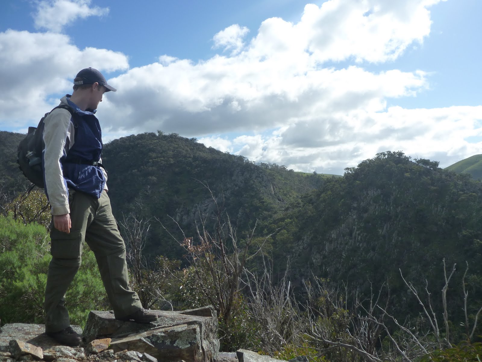
After an hour we come to the start of the Swindlers walking track which headed in a south direction and it wasn't long before we hit Derrick Hut . At this stage we were still 1700mt high and there were great views to the south. The track was well defined and at every 40mt there was a 15ft wooden pole .


As we started to make our decent we headed into the snow gum forest, and continued down to the fast flowing Cobungra River. the track got quite steep near the end as we dropped down to 1300mt.


We had walked 9km, it wasn't even 4pm yet and there was plenty of daylite left, but we wern't going on. We had arrived at Dibbons Hut and new that this was the place that we wanted to spend the night.


The old log cabin was set in the middle of a grassy field , next to a flowing river and surrounded by mountains. Absolutely beautiful.


After setting up the tripod for the group shot we lit the fire, set up tents and relaxed just as the light rain started.


We rose early to clear skies and as I ate my porridge Kev was cooking up a storm, eggs, bacon, mushrooms. We left at 8.30, crossed a small foot bridge and headed north. It took us just under and hour and a half to reach Blairs Hut where we stopped for a break. As we were de-packing by yet another great looking log cabin which is on the West Kiewa River we were surprised by a person coming out of the hut in his PJ's which were pulled up to his chest. Harry was welcoming and told us he was staying in the hut for a few days. He had wire hoops everywhere that he used for a game of croquet. Harry mentioned that he had climbed Diamantina Spur over 10 times and it was tough, especially the first section.


We left Harry to his croquet and continued north along the river, mostly slightly downhill. At 10.55am we had reached the start of the dreaded Diamantina Spur Track and we prepared for the 3.9km climb to the Razorback.


The first hour was completely uphill with no flat sections. At times we had to scale rock faces and navigate ourselves around cliffs. There was a track the whole way but was tough to find in places. As we got higher up the mountain the track slowly started to get easier but it was still an uphill slog.


About 2 hours into our climb up the spur we stopped for lunch on a grassy area with sensational views of Hotham to the south, the razorback and the incredibly powering Mt Feathertop to the north.


As we continued our trek up the spur we could see a group of 10 walkers on the summit of Feathertop far in the distance. The south face of Feathertop had huge pieces of ice on it. Near the end of the track there was a pretty good camp site not much before the junction of the Razorback. If you had some water left from the climb it would be a good spot to set camp as there wouldn't be anyone there. At 2.10 we had reached the Razorback. It had taken us 3hours, 15min to climb the 3.9km spur with full packs. Hard work but rewarding as we had a great view of the spur from the top and a massive scence of achievement.


We had walked about 15 min along the Razorback towards Federation Hut when the weather started to turn. The clouds rolled in and the mist turned to light rain. From this point on our views were gone. Feathertop had disappeared and it was out with the full wet weather gear.


We arrived at Federation at 2.50 and thought I was back in the city with people everywhere. Tents spread all over the place and we figured there would be at least 20 hikers,if not more camping there that night. We had a quick think and looked at the map and decided to head for the MUMC Hut which is located 2km down the North West Spur.


As we walked back toward Feathertop to the North West Spur we come across another group of hikers who were heading to the MUMC as well. They had just come from the summit and said it was pointless going up as you cant see a thing.


About 500mt along the Northwest spur there was a fast flowing spring with heaps of fresh water. It took us an hour to get from Fed Hut to MUMC hut in poor conditions but we were glad to get inside and start drying off.


There was water at the hut but no fire place and no fires are allowed up there so hiking stoves are required.


The rain didn't ease all night and after Brent finished the port and we had a few games of Uno it was off to bed. The hut would easily sleep 20 hiker. Today we covered almost 15km.


The morning was no different, the rain continued and didn't look like easing. Our gear dried a little overnight but we knew the walk back to the car was going to be interesting. We left at 8.40, walking through what resembled a river. The water flowing down the mountains made the tracks soaked. We hit the start of the Razorback at 9.30 and started our final journey back to the car.


At no time could we see more than a few hundred metres so the famous views from the Razorback weren't to be today. Three hours of hard walking saw us get to Diamantina Hut at 12.30pm. We passed a few groups that were returning from Federation Hut and like us were looking forward to some dry cloths.


A short half hour walk along the road saw us back to the car at Mt Lock car park with the weather exactly as it was when we left on the Friday arvo. We had just walked 14km, 13.8 of which our feet were soaked.


This was an amazing trip even though the the rain spoilt the last part. I would recommend the course we took highly as staying at Dibbons Hut was a highlight and the walk up Diamatina Spur was challenging but rewarding.

Sunday, October 17, 2010

Dandenong Rangers National Park


1000 Steps


October 2010 and the family and I wanted to give the famous 1000 steps a go in Ferntree Gully. We arrived mid arvo on a cold, drizzly day thinking it would be quiet, but we were wrong, it was packed.


We parked in the Ferntree Gully picnic area at the base of the mountain with the signs saying that the 1000 steps were 800mt up the Kokoda Memorial Track.


With my son on my back and daughter along side we head off with my wife close behind.


The 800mt walk to the start of the steps was an easy uphill stroll with memorial plaques lining the side of the track.


At the start of the steps the track narrows dramatically and with lots of walkers and joggers it was very tight in spots.

From here to the top is about 1.7km, uphill and it was tough, especially with Baxter on my back. My 5yo daughter did really well, she walked 2/3 of the way, I carried her the rest. There are rest areas along the way which we took advantage of.


Except for the loads of people the walk was beautiful, the stream was flowing nicely after recent rain and the trees and ferns looked great.


It took us about 40min to reach the top from the car park where we had a well deserved rest and gave Baxter a run around.
The walk down was just as hard and while the kids had a play on the playground in the picnic area I thought I would go back up by myself, without the pack, to see how long it would take.


I gave it a good crack and got up in 9min with 7min to get back down, from the base of the stairs.

Good walk on the day, I wouldn't want to go there on a nice day, I'm tipping it would be packed.


Werribee Gorge

Circuit Walk


It was late August 2010. Brent and I decided to tackle the walk which is quite popular for day hikers in the area. The Werribee Gorge is 10min past Bacchus Marsh along the Western Hwy.


So far we have had a wet winter which meant the river would be up and flowing. We parked the car at the bottom picnic ground, Meikles Point and set off on the 8 km circuit walk around lunch time.


We head in an anti-clockwise direction up the track towards the Quarry Picnic area and continued up to the Eastern Viewpoint. After taking in some great view to the north the track kept rising until we hit the top at Picnic Point. It took us a bit over an hour of complete uphill walking to reach this magnificent lookout which looks down into the gorge and you can see the walking track far below near Needles Beach.

From here it was along the ridge and we started to make a slow decent into the gorge to meet up with the river. I really enjoyed this part of the walk as the track was narrow in places with drop offs on either side.


We soon hit the river and it was flowing nicely. We wound our way along the river where we stopped for a 15min break at Needles beach. This was quite a large pool and looked like a good swimming hole in the summer.


The track continued along the river and there were parts where we had to do some serious rock hopping to keep ourselves from getting wet. This was great and challenging at times.


After passing Pyramid Rock we came to a section where you had to use a thick wire rope attacked to the rock wall to keep going. This bit was cool and it was now an easy walk along the disused aqueduct back to the car.


he walk took us 2.5 hours and I enjoyed it a lot.


WERRIBEE GORGE


Take 2


Early Jan 2012 and it was time to kick of my wife Tammy's and her mum Lynne's training for a mid year conquer of Mt Bogong. The aim for today was the 8km circuit walk around the Werribee Gorge.


Tammy and Lynne have a moderate level of fitness and are beginner hikers so I was allowing 4 hours for the circuit to be completed.
Leaving the Quarry Picnic Area at 1pm on this overcast, 30 degree day, we headed in an anti-clockwise direction.


Having a quick stop at all the lookouts we cautiously made our way down to the river which was surprisingly flowing nicely.


We stopped at 2.45 at Needles Beech for a rest and I had a nice swim in the watering hole. It was beautiful.
We left at 3.15 heading towards Meikles Point. Tam and Lynne did great over all the rocks and shimmering around the cliff faces.


After passing a few people having a swim in the poles closer to the car park, we hit Meikles Point Picnic Area at 4pm then continued uphill for the last and hardest part of the walk arriving at the car at 4.30 for an icy cold pepsi max that was awaiting.


3.5 hours was a great effort and a good start to the longer more difficult walk that awaits the girls later in the year.

Monday, August 23, 2010

Mossman Gorge

Tropical North Queensland


While on a holiday in Cairns with the Family in August we decided to hire a car and take a drive up to Mossman and have a look at the Mossman Gorge in the southern end of the Daintree National Park. The drive alone along the coast was great. Once in Mossman the gorge is only 4km out of town. After we parked the car just outside the aboriginal settlement we boarded the free shuttle bus that took us to the start of the gorge.


We set off along the walking track. There was myself, wife Tam, Bethany(5) and Baxter(2.5). The track followed the crystal clear, pristine, fast flowing river. It didn't take us long to realize that this place was amazing.


We followed the easy track to a number of lookouts that made for great photo opportunities.


Like ourselves, there were a lot of tourists in the gorge and some even decided to swim in one of the many ponds. The water was so clear that hundreds of fish could be seen from the bank swimming around

We continued along the track, crossing the river on an suspension bridge and taking in more beautiful scenery when we come to a divided track that was a circuit of 2 km but we didn't proceed as the kids little legs were tiring.


The slow walk back to the bus was just as amazing with regular stops along the river.
Everything was just so green. I'm looking forward to hopefully in the future returning when the kids a older so we can explore the gorge further.


Saturday, August 21, 2010

Mt Whitfield. Cairns


Cairns. North Queensland


August 2010 on a holiday with my wife and 2 young children to Cairns I was keen to explore a conservation park only 10min walk from our Hotel. (The Lakes).


The park is in a rainforest about 4km north of the main City of Cairns, just near the airport. There are 2 walks that can be done. The first is the Red Arrow Circuit. A short walk that works its way uphill through beautiful rainforest to a lookout that takes in views of the Coral Sea and Cairns. The return journey down the other side of the mountain also has great views. This walk is only 2 km and wont take more than a hour.


While at the top of the Red Arrow Circuit walk there is the start of the longer Blue Arrow Circuit Walk. This walk takes in the peak of Mt Lumley and is about 7km long.


Time was limited on the morning when I set out to do the Blue Arrow Circuit and even though its winter in Cairns it was very hot and didn't take long to work up a sweat.


After taking in a few good lookouts it was into the thick, lush green fainforest and the track was narrowing and becoming very rough. After about an hour I had to turn around and head back, again taking in the great views of Cairns and The Coral Sea.


This walk would take 3-4 hours to complete and if I'm ever up in Cairns again I will make sure I have time to do the whole thing.


Friday, June 25, 2010

Langi Ghiran


Langi Ghiran State Park.


June 2010.


Its mid winter and we decided to do a walk in the Langi Ghiran State Park. Its located just off the Western highway between Baeufort on Ararat.


We parked the car at the southern most car park and headed off along the Lar-ne-Jeering track at 8.15am. A short easy walk saw us arrive at the Aboriginal shelter and art work.


The Parks Vic guide suggested off track walking is OK so we headed north for the peak of Mt Gorrin. 757m. This took a bit of climbing and as we ascended higher the thick bush thinned out to reveal large sections of slippery rocks. Navigating our way to the top took time and required great care but we were rewarded once we hit the summit.

The views of the Grampians were great but as we cast our eyes north we saw our next challenge, Mt Langi Ghiran, 949m.


To get from Gorrin to Ghiran you have to go straight down then straight back up, even higher. We headed north zig-zaging our way down My Girrin and at stages slidding down damp rocks. We arrived at the base of the mountain where it flattened out a little then we hit the track that runs east/west between the 2 peaks. As we walked along the track towards Hidden Lagoon we started to make the accent to Mt Langi Ghiran.


The lagoon was nice but bone dry, even in the middle of winter, good spot to camp. It took us about 3 hrs to reach the lagoon and after a short break it was time for the main peak.


So far the weather had been perfect with great views all round but once we got higher than about 850m we were in the low clouds and couldn't see a thing. Everything near the top was soaked and there were thick shrubs to push through that were difficult. It took a huge amount of care to make the summit as the rocks were like ice but we got to the top about midday where we had planned to stop for lunch. If I were to guess it would have been about 2 degrees, absolutely freezing so we found a spot out of the wind, had a quick bite to eat then it was back down. Once we got off the peak the views returned and it made the walk down to the mountain enjoyable.


We followed the track west until we hit the Langi Ghiran Track, then south, arriving back at our car at 2pm.


This was an absolutely brilliant walk, to stand near the top of Mt Langi Ghiran and look back and realise we just climbed over Mt Gorrin gave us a huge sense of accomplishment.


Monday, May 10, 2010

Lerderderg Gorge Walk


Early May 2010, myself(with stick) and 5 mates all in their mid 30s decided to walk the Lerderderg Gorge along the river from Darley to Blackwood.

It was 8.30am Friday when we left from just near the Darley footy oval.
We walked along the river up to Mackenzie Flat picnic ground which took us about 1.5hrs.
After a short break we were off along the track.
The first thing we noticed that the river had little to no water in it so we were glad we filled up our bottles before we left.
Not long into the walk the first group decision had to be made.
We had reached the very steep Spur Track and had a choice of going up, or continuing along the river.


Up it was, and it was tough, but great. To turn and look back over the gorge towards Bacchus Marsh was good and we all felt a sense of achievement when we reached the top.
An easy 40min walk down to the Lerderderg Weir at Long Point saw us get there by 1pm for lunch.

From here on there was no track so we had to follow the river bed and we soon realized that reaching our intended camp for night one of Ah Kow Ruin was going to be a struggle.

The river bed was hard. You had to watch every step and there were areas that were completely overgrown with prickly shrubs that we had to push through.


We also came across sections of river that actually had water in it and to navigate our way around took time.


We reached Bears Head Track at 4 and decided to camp at a pretty good site just at the start of the track. Camp sites along the river are few and far between so we didn't want to push on.


Day 2 saw us leave at 9.30 after boiling up our days water. We reached Ah Cow in just over an hour and was glad we stopped to check out the mine. Great camping here aswell.


After a quick stop it wasn't long before I realized we had a problem. Paul, one of our more experienced walkers in this region was struggling after he twisted his knee in this unforgiving river bed.


We soon noticed that a group is only as fast as its slowest walker and we were not making good ground.


We decided after lunch to split the group up. The lead pack of 3 would push for O'Briens Crossing and meet up with another mate who was coming down in his car.


I stayed back in the second group of 3 and along with Kev we limbered on carrying what we could of Paul's gear.


By 5pm we decided to set camp, just off the river a few hundred meters past the Razorback Nth Track. The camp site was small but set in the ruins of what looked like an old minors house and the location was beautiful.


The lead group chose to take the Cowan Track up to O'Briens Rd and then down to the crossing. The Cowan track was very steep and the group arrived at the crossing under torch light at about 7pm.

Day 3 we were off at 7.30am and it was a huge relief to be out of the riverbed and onto the East Track.


We noticed the large mine camp, situated at the end of the Kenworthy Track on our way to the crossing. This would be a great spot to set camp on night one if doing the walk from Blackwood down.


It took us 4 hours to reach O'Briens Crossing but the walk should normally only take 2-3hrs.


As we were walking along the East Track and getting closer to O'Briens Crossing everything started to become greener. There was more water in the river and the ferns, along with the moss covered logs made for beautiful scenery.


It was good to meet up with the others at O'Briens Crossing and talk about the previous 24hrs.


After a huge effort to walk the distance and terrain he did, Paul was driven out from here and we started the 12km walk into Blackwood along the Byres Back Track.


It was nice to walk at a normal pace and the track was easy compared to what we had just done.


We got to the Tunnel and decided to walk down the steep hill to have a look at the hole the minors dug in the rock wall to divert water.


The walk from O'Briens Crossing to Blackwood took about 2.5 hours.

After 3 days it was beer and BBQ time.

This walk was amazing and I would recommend it to anyone who is up for a challenge.


Its hard to describe the beauty of the gorge. Huge cliff faces and picturess scenery is just the beginning. Those who have been in it will know what I mean.


Wazza's tips for this walk.


Wear pants or long gators when in the river bed. Our legs were ripped to shreds but the cuts were worth it.


Try to avoid camping at O'Briens Crossing. It was busy with loud music late into the night. Because it is a popular camp site fire wood was difficult to find.


Walking through the dried river bed was tough. Pushing through the overgrown shrubs was the worst part. Walking down stream instead of up like we did may have made it easier, but after years of drought and no flowing water for a long time, I don't think it really mattered.