The following morning we were met by my cousin Nicole at the bottom of the Bungalow Spur Track in Harrietville at 8am, where she took us to the top of Mt Hotham for the start of our overnight walk.
After the 40min drive up in thick cloud we were dropped at the start of the Razorback at the Diamantina Hut. The forecast was good but right now we couldn't see a thing.
With memories of our last trip to Feathertop fresh in our minds where it rained and was miserable, we were hoping for some nice views.
Thanking Nicole we were on our way by 8.45am with another couple of small groups gearing up also. Within minutes the clouds cleared and we were in amazement of what we were about to tackle.

It was icy with the temp hovering around zero degrees but we had blue skies and could see Mt Feathertop in the distance with still a bit of snow on the south side.
With great views all around, the Razorback was looking at being a fantastic walk on a day like today. There was quite a bit of fire damage to the trees and shrubs from the previous summer and in some places looked very desolate.
We made good time but still took in all that the Razorback was offering.
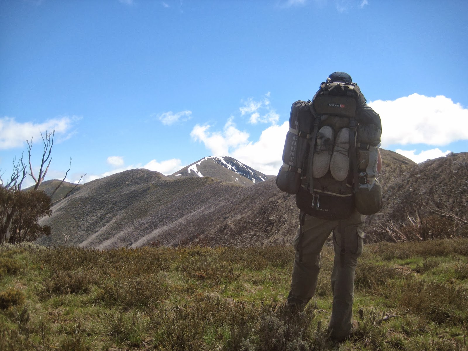
After passing Twin Knobs and High Knob we arrived at the junction of the Diamantina Spur Track at 11.30am. Along the way there were great views of Mt Hotham, Mt Lock and also Mt Buffalo, and of coarse, Mt Feathertop.

By midday we had arrived at Federation Hut. Not the best looking hut in the high country but a nice place to camp the night. There is plenty of flat grassy area to pitch a tent, tank water available and only a short distance to the Feathertop summit. We had a bite to eat for 30 minutes, wraps with peanut butter and jam, then continued toward the summit.

As we began to climb we passed the turn of to the MUMC Hut, and decided that we would stay there for the night. We dumped our packs 100mt up the track then started the steep 1km climb up the well defined track toward the summit.

There were large patches of snow on the non wind effected south face of the mountain which were great to have a bit of a play in on the way up to the summit. The going was steep but no worries as we had no packs on and there were amazing views in every direction.
As we neared the top, coming down were an excited couple who had just go engaged on the summit.
By 1pm we had reached the summit of Mt Feathertop, 1922mt above sea level.

There was no markings to indicate the highest point but it was obvious as this was a real mountain summit, not like Victoria's highest peak, Mt Bogong where you felt like you were in the middle of a huge paddock.
We met another couple of hikers while we were up there and while taking in the 360 degree panoramic views, it was great chatting to them about other hiking adventures.

Still thrilled with the recent Hawks premiership I flew the flag on the summit for the group shot before we started the decent back down. We could clearly see the MUMC Hut which is 2km down the Tom Kneen track and knew that it would be deserted as everyone was staying at Fed Hut.
We had spent about half an hour on the summit and by 2pm were picking up our packs and making our way toward the MUMC Hut for the night.

The trees surrounding the track heading toward MUMC were was very badly burnt. The views down the valley looking toward Bright were great and it wasn't long before we had reached the spring where if we needed to we could fill up out water bottles. We had enough water and knew that the MUMC had a tank so we continued on.
The track zig zaged its way along the ridge with a few small climbs and descents before we had reached the hut by about 3pm.

A nice cuppa was in order as Brent heated some water on his metho cooker. Unfortunately due to the fires earlier in the year there was no water available at the hut which wasn't a problem as we had heaps. With the clouds starting to roll in we enjoyed the tranquility and took in all that was to offer from this beautiful location. Our tranquility was short lived when at about 4pm we heard some voices, and 3 other hikers arrived. There is plenty of space so all good but the leader, Floki informed us that its his birthday and to celebrate he an 10 friends and having a party at the hut. One by one the party crew rolled up. We were not disappointing as there were attractive females in the group so we geared up for what was going to be an interesting night.

The sunset was appreciated to the sound of some weird music coming from Floki's Party Crews stereo. We noticed a tent set up just of the summit of Feathertop and saw the occupants enjoying what would have been some amazing colors in the sky.
As the sun set, the party rose, with dancing, plenty of wine and generally a bit of a celebration. Our new found friends were good, respectful of where we were, just a bit younger and enjoying themselves. Some of the guys had some hiking tales to tell.

By 9.30 I was done so called it a night, and it wasn't long before everyone followed. The top sleeping platform of the hut sleeps 15 so the 3 of us and the 11 of them all found a spot. It was a very cold night, and I think there were a lot who endured a restless sleep.

We woke to a beautiful morning and it didn't take long to warm up as the sun rose above the surrounding hills. The snow covered Mt Bogong was clearly visible this-morning and I enjoyed my coffee and porridge overlooking the breathtaking views.

Three of the other group needed water so they made the 1 hour round trip to the spring while the rest of the group slowly rose. By 8am Brent, Kev and I were ready to go. We said good bye to the others as they started their breakfast and cranked up their music, and headed back toward Feathertop.
We wanted to climb to the summit again thismorning and as we walked away from MUMC we could see a possible route up one of the ridges on the north side.

The top section of the ridge looked quite steep but doable. We had walked for about 20min when we decided to leave the track, just before the spring and start the climb.
With our packs a lot lighter than the previous day it meant that the climb wasn't that difficult. It did get steep near the top but the ground was dry and firm so safe. Caution was needed as a fall from this ridge would mean certain death as the drop was hundreds of meters with nothing to stop your fall.

We were on the summit by 9am and enjoyed magnificent views. We could clearly see our party friends still relaxing along side MUMC so we got the hawks flag out again to give them a wave. The tent that we had saw near the summit the night before was packed up and gone.
After abut 20min we started the walk down to Federation Hut. There were a few groups making their way up to the summit thismorning as the sky was blue and the wind, even though icy, was calm.
By 10am we were having a coffee at Fed Hut. A couple of hikers were there so we traded stories from our journey.

We were all OK for water so didn't need to refill so by 10.30 we were reluctantly on our down Bungalow Spur Track. It wasn't long before the mountainous views that we enjoyed over the past day were gone and we were within the trees and shrubs.
We pasted the Old Federation hut site, the Bungalow Hut ruins before reaching the wet area where there was a spring. A few people were making their way up as we continued down the long and winding track.
The forest had significant fire damage, probably the worst that we had seen on this walk. We also had glimpses of Harrietville as we got closer to the bottom.

By 11.50 we were at Tobias Gap, 40min later we had reached Picture Point, which was to be our last short 10min break before we finished. A nice view of Harrietville was taken in before the last part of the walk. By 1.15 we were back at the car, relieved as the Bungalow Spur was long and and compared to walking the Razorback, a little uninspiring.
We had walked a total of 28km over the 2 days and for me, taken in some of the best scenery to date.
What can I say about this trip but "WOW". It was probably one of the most enjoyable hikes I had done. The weather was perfect, the views were amazing, as always the company was great and climbing the north face of Feathertop was a reel buzz. The girls weren't bad either.
Having climbed the tallest mountain in Victoria (Mt Bogong) 3 times, I would safely say that Feathertop was a better peak to climb. You really get a sense of being on a summit on Feathertop, where Bogong is great, but the view aren't as good as Feathertop. Great 2 days.

And it was nice to get home, unpack my bag to find a few of the girls phone numbers in the top pocket.


