Hells Window, Mt Howitt circuit.
Autumn in Victoria, perfect weather and a great time of the year for an overnight walk in the high country. For a few years now I have had the Buller-Howitt Alpine Area map and been keen to do something in this region. After a few Google searches, Helicopter Spur kept popping up as something that seemed really exciting and challenging.
The plan, Day One, climb Helicopter Spur and camp at Hellfire Creek, Day two, descend Howitt Spur back to the car.
Brent and I drove up Friday arvo. Kev was absent on this one but hope to have him back on board later in the year.
With our last walk up Feathertop still clear in our mind, we were hoping for nice weather as the mountainous views in this region are suppose to be amazing.
About 40 minute drive past Mansfield we had arrived at the Telephone Box Junction on the Mt Stirling Rd.
Telephone Box Junction.
It was 6pm and we were going to roll out our sleeping mats in the public shelter, but decided to push on down the Circuit Rd to the Howqua Gap Hut, much better decision. The 7kms on the unsealed road took 20min and we were greeted by a great bush hut, perfect spot to relax before the hard day to follow.
Howqua Gap Hut.
As we were getting relaxed, a father and son arrived on their mountain bikes, out of water and glad we could top them up as they still had to get to Mt Buller and it was getting dark.
The pot belly stove in the hut worked a treat, we were more than warm, I think maybe that last log before we went to sleep was a bad idea as we sweated through the night. Was a pleasant evening, a few beers and listening to the Hawks just get over the line over the Bombers.
Driving down Circuit.Rd
We woke to a perfect morning, bright skies, dewy ground and no wind, and it wasn't long before the nerves started to kick in as we had heard and read a lot about the infamous Helicopter Spur.
We packed up and started the journey at 8am down Circuit Rd. We were at 1400mt above sea level and new we had to drop down to well below 1000mt.
The road was fine and by 8.15 were were making our way down Bindaree Rd, arriving at the Upper Howqua Camping Area by 8.30am. In dry conditions a 2wd would make the trip no worries, maybe a bit slippery if wet.
The camp site was deserted as we expected. There are no indications on where the Helicopter Spur track starts but I had read that it begins on an old 4wd track, which wasn't easy to find. The camp site is quite big so by the time we found the track and geared up it was 9am. As always I made sure Brent had turned his lights of so we don't return to a flat battery as we have in the past.
Overgrown 4wd track, start of Helicopter Spur
Just as you cross the concrete bridge, to the right there are 2 large logs across the disused, overgrown 4wd track, this is the path you want to take. We were slowing climbing in elevation and within 15 minutes we were peeling of the layers. The track was completely overgrown and thick in parts, but always distinguishable. By 9.40am, and after an easy 1.7km walk, the 4wd track ended. To the left there was a small walking track that led up onto the spur.
Lower section of the spur.
The walking track was quite easy to follow and as we got higher, nice views back toward Mt Buller were to be seen. The spur was very well defined and by 10am, it was getting very rocky, a sign of things to come. By 10.05am, just over an hour since we had left the car, we saw it for the first time. A huge wall of towering rock that leads up to the sky, and we both just stood there for about 10 minutes, thinking how the hell are we getting up there, holy crap.
After gathering out thoughts for a bit we set of, again following the track and by 10.30 we had hit the first rock band. I had read that there were three rock bands to navigate up, we were now standing at the bottom of number one.
Base of rock band one.
It looked impossible as we were standing in front on a vertical wall of rock, but we stuck to the left as I had read and we could see the clear route up. With plenty of foot holds and a lot of concentration, it wasn't that hard and we were soon half way up the wall.
Extreme care did have to be taken as to fall over one of these edges would mean curtain death, but in saying that, the way up was quite safe. It was also great to take in where we were, the landscape was spectacular and the scenery was amazing.
Half way up first rock band.
By 10.45 we were at the top of the first rock band, knowing that the second was to be the hardest, and straight away we could see what we were in for. We walked along the track for another 10 minutes before we were standing at the bottom of RB2.
Bottom of rock band 2.
We again headed left, looking out for a way up. The track suddenly ended, "wot the hell", we looked up and thought, "that cant be it", but it was.
Brent starting his climb up RB2
This is the section where we had heard reports of hikers using rope to lower and lift up their packs. It was definitely steep, and I couldn't imagine climbing anything steeper without being a serious rock climber.It would have been 20-30 mt up a narrow channel between 2 rock walls, but there were plenty of footholds so we inched our way up without a problem. I stayed back from Brent as I wasn't keen in being taken out by his skinny, sun deprived Ballaratonian body, if he fell.
With 18kg on our backs this was tough, strength and fitness is needed to get up RB2 if carrying a loaded pack, but we finally made it and de-packed for a well deserved breather.
We set of knowing that the hard part was done, and by 11.30, we were at the base of the final rock band, and unlike the past 2 rock bands where we had to stick left, RB3 had to be navigated to the right. It was still very steep with long drops over the sides, and in no way we eased of with our concentration. By 11.40 we had made it to the top and were now making the slow and tiring walk to meet up with the 4wd track.
Atop the Helicopter Spur, Mt Buller in the distance.
By 11.45, we had reached the 4wd track, we had conquered Helicopter Spur in under 3 hours. My thoughts about the spur, wow, it was amazing and a lot of fun. Care had to be taken but at no time did I feel fearful of losing my grip and going over the edge . The way up was very obvious. One thing is that we both couldn't imagine going down Helicopter Spur, it would be a lot more dangerous and I think not as enjoyable.
There was a camp site at the top just of the 4wd track, we continues on a little until we had a nice shady spot overlooking Mt Buller and Mt Stirling, great spot for some lunch.
By 12.15, after a well earned break, a banana and a few wraps with peanut butter and jam, we were on our way, still following the rocky 4wd track, slowly climbing in elevation. 30 minutes later we were at Picture Point, which had a sign post that we felt strange as nothing so far was sign posted. It was well worth dropping the pack and taking the short 2 minute walk to enjoy the amazing views.
View from the appropriately named Picture Point
We made our way along the 4wd track and was soon surprised to see a sign for King Billy No.1. We had missed the turn of to the AAWT. Back traced a little when we saw a little track and an arrow, clearly miss-able from the direction we had come from. It was 1pm and we were making our way to Mt Magdala along the the walking track, enjoying the best views and huge cliff faces that dropped bellow us.
By 2pm we were at the folk in the track, go left and avoid climbing the summit, or go right and climb to the top after already lugging what seemed like a fridge on our backs up Helicopter Spur. The decision was simple, any chance we get to summit a mountain, albeit a small one, we will take it, so up we went.
Mt Magdala, 1726mt
We know we were getting high as the normal trees and shrubs were replaced by the beauty of the Snow Gums and the baldness of the terrain.
As the trees cleared the breeze started to become chilly, another indication that we were nearing the top. We were then welcomed by a 15inch Brown Snake blocking our path. Last thing we wanted to do was disturb it as it was taking in some rays, so we detoured around it and found ourselves on the summit by 2.20pm.
Sitting on the summit of Mt Magdala was a highlight, the sun was shining, the skies were blue, the light wind was cold and the 360 degree views were as good as we had seen. We sat there for 15 minutes or so just taking it all in.
Brent enjoying the views from Mt Magdala.
From here we made our way down, looking over the side of the mountain at the track below that leads along the lower part of Magdala. The cliffs and rock formations in this area are amazing.
Looking down from Magdala. You can see the lower track if you look carefully.
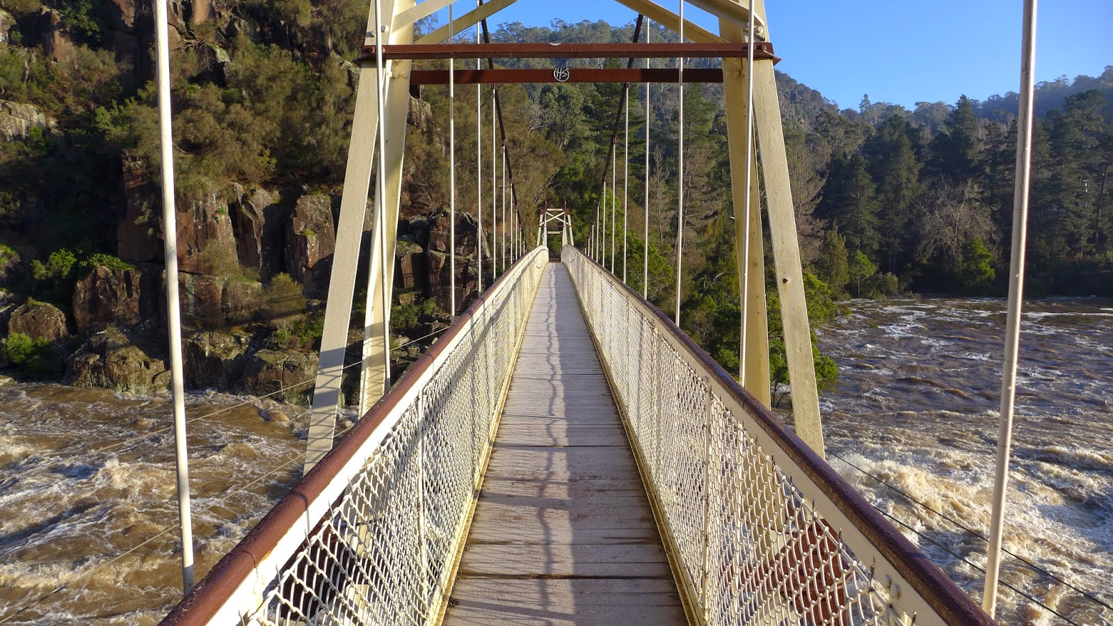
Ten minutes after leaving the summit we were at Hells window. Sorta like a opening in the massive rock wall that looks over the mountains, fantastic spot. We even found an old, half burnt sign that needed to be included in our pics.
Hells Window
Not long after leaving Hells Window we met up with the lower walking track and decided to turn left and have a look at Hells Window from below, and to also see if there was anywhere cool to set up camp.
Hard to camp on the side of a mountain so we turned around and headed back along from where we came. A short 10 minute walk and we were at the perfect camp spot. Large flat grassy area which was going to be perfect to pitch out tents and get a good night sleep after a tough day.
Now for the important part, water. I had read that there was water available 12 months of the year at Hellfire Creek, which was directly below us. It was 3.20pm, we were knackered but wanted to fill our bottles. The track down to the creek was steep, the last thing we wanted at this point, but down we went to what was a very slow trickle, which is understandable as its the end of a very dry summer.
By 4.30 camp was set, fire going, boots removed, and coffee going down a treat, and the port after dinner the the perfect way to end what was a great day.
After probably the best sleep I had ever had on a hiking trip, the morning was totally different to the previous day. Stumbling out of my tent at 7am, we were greeted by light rain and gloomy skies.
We packed up camp and were on our way by 8.15am. The rain wasn't that heavy, we weren't getting soaked yet and there were glimpses of blue shy and still some nice scenery. As we continued toward Mt Howitt, we come across a couple of deer hunters who were perched up high waiting for a target. After a 10 minute chat to them we pushed on into the misty conditions.
Just after 9am, we come across a camp site, a great location just before the snow line within the trees, not far from the Howitt summit.
Darkened skies on the way to Mt Howitt.
We arrived at the track that led us down the mountain via Howitt Spur, but we weren't done yet, we had one more peak to conquer. The rain had stopped, the clouds still looked threatening but we wanted to continue.
The darkened clouds looked amazing over the endless, mountainous terrain. By now our bots were soaked, not only from the rain, but from the wet grass. For the first time I contemplated zipping on my pant bottoms, but na, all good.
By 9.30 we were on the Summit of Mt Howitt, 1742mt above sea level.
Summit of Mt Howwit.
As the wind now become icy, the clouds cleared long enough for some amazing views of the Crosscut Saw, which is definitely on the list to smash out. We could also see a group walking the Crosscut in the distance, but this was short lived, the rain started, and was getting heavier. Being above the tree line in these conditions aren't fun, so it was time to make our way down. We had West Peak to climb over before the journey down the mountain.
Walking up West Peak, the view was nil.
The first section over West Peak was steep and rocky, and being wet, was a bit hairy, but didn't last long and we were soon within the shelter of the trees again.
The weather soon cleared, the clouds thinned and the views we were so used to for the past day had returned. The walk down Howitt Spur was straight forward, like any decent from a mountain, by the end your knees are screaming for a break. We hit the bottom and the river by 11.40am.
The hour walk back to the Upper Howqua Camp Area was nice. The track followed the river all the way, with quite a number of river crossing. We could see through the trees the towering mountains above, and it now you realize and feel a great deal of accomplishment.
A dry change of cloths was in order when we had returned to the car, and of coarse a cool can of Pepsi Max.
Im not sure what it is, weather we are picking better locations to walk, or are just well prepared, but our adventures seem to get better every time, and as soon as we finish one walk, we are talking about the next.
The one big absents from this trip was Kev, didnt feel the same without him, but hope he is all good to go later in the year, and we might have another join our crew next time also.
The 2 days we had walked just over 22km.
Cant wait to get back up to this region, and I could walk Helicopter Spur many times as it was the best of fun.


.JPG)


