Wednesday, November 23, 2011

Cairn Creek Hut. Mt Bogong

Our mission was to find and camp at Cairn Creek Hut which is located on the Big River at the base of Mt Bogong, Victoria's highest mountain at 1986mt. From what I can gather from reading off the net is that the hut hasn't been visited for a while due to the fact that the 2km track leading to it is extremely overgrown.


From west of Melbourne myself, Brent, Kev and Jonah drove up to Tawonga on Thursday night and stayed at a mates van at the caravan park.
The forecast for the weekend wasn't great but but as we rose Friday morning it looked fine and I just wanted to reach the summit before the clouds rolled in.

After gearing up we left Camp Creek Picnic ground at 8am and made our way along the 4WD track until we had reached the start of the Staircase Spur at 8.40. We were at approx 600mt above sea level, knowing that the next 5km we had to climb another 1400mt. We removed clothing as it was starting to heat up and was very humid.
As we started the 5km climb to the summit the sweat started to pore out. We had a quick 10min breather before continuing to Bivouac Hut where we rested for 30min. It took us almost 2hours to reach the hut which is half way up the Staircase Spur. The views from here were starting to open out as we were now well over 1000mt up.

We left Bivouac Hut at 11.05 and continued up, passing through the beautiful snow gums with great views all round.

We had a clear view of the Eskdale Spur and could see the Michell Hut amongst the trees. Brent found the going difficult up the staircase but dug deep and pushed on. As we broke through the tree line light cloud started to roll in but nothing serious. The track was still well recognizable specially with the snow poles beside it.

Passing the memorial the temperature dropped as we climbed higher, reaching the summit at 12.45pm.

Lunch on the summit was great, the cloud cleared and the views were amazing. I didn't realize how much space there was up here, easily fit a couple of footy ovals and except for the summit cairn, it was hard to tell we were at the highest point in Victoria.

At 1.30 we decided to start our 6km trek down Quartz Ridge. Two km along the ridge we were at Hooker Plateau and to look out to the west and back toward the summit was something that we just couldn't walk by. We spent about half an hour just taking in the breathtaking views.


Still above the tree line we continued over quartz knob with clear views of the fast flowing Bogong Falls.

The section after Quartz knob was really cool. The cliff faces and rock formations were great. We started to drop rapidly from here on and were soon back amongst the snow gums. The scenery was great but the ants a huge problem. We couldn't stop for a minute without being covered in ants. Plenty of good camping from Quartz knob to the bottom but on this day there was no way we could stop for a second, let alone set camp, without being eaten alive.


Bit later than expected but we reached the bottom of Quartz Ridge at 4.30pm, 2km to go to Cairn Creek hut. There was a sign pointing to the hut and a faint walking track. I had read that the track was overgrown so I estimated that the final 2 km should take no more than 2hours and we would be at the hut at 6.30.

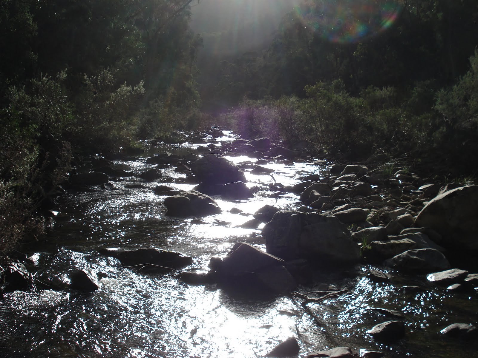
We hadnt been able to fill our water since Bivouac Hut and with a hot humid day we were all running low. We started the slog toward C.C.Hut and a couple of hundred metres in realised that this was going to be a struggle. The track was really hard to follow, the only thing keeping us from loosing the track was the orange arrows on the trees. These soon disappeared as the undergrowth was over our heads and visibility was zero. This soon become the hardest 2 hours walking Ive done as we had to carve our way through thick shrub, shimmer down fallen trees and be cut to shreds. We were now clearly off the track and fighting a lost cause. We could hear the river below so decided to try and make our way down to it and set camp. We finally found a clearing down to the Big River and the relief was amazing as we were done with fighting with the bush.

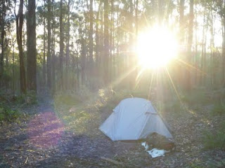
As we stepped into to clearing with the river now in sight, our enjoyment was short lived as within a minute we saw 2 snakes basking in the sun, the last thing we needed. We finally made it down to the Big river, crossed it and set camp at 7pm. We had travelled about 1km in over 2 hours and were glad relax around the fire, thinking of what to do tomorrow.


With steady rain all night the decision was easy, return to Quartz Ridge and camp at Michell Hut. At 9.30 we left the Big River and climbed back up to the ridge. We actually found the track on the ridge but it didn't look any better and we were done with fighting the bush. It took us 2.5 hours to get to the base of Quartz Ridge as we were constantly burning leaches off each other.


We had a break, de-leached and took off up the ridge at 12.15pm. The weather was OK, the rain was holding off and we stopped for lunch on Quartz Knob at 1.30. Again the views were unreal across the valley and toward the summit.

The clouds were blowing in, and out just as quick as we left at 2pm, heading for the summit. The rain started and continued to get heavier. It started to become very windy as we climbed to over 1800mt. We reached the summit at 3.30, the clouds cleared briefly as we hid behind the summit cairn for 10min just to get out of the wind. From here it was down the very steep and rocky Eskdale spur.


The hour walk from the summit of Mt Bogong to Michell Hut was the worst for weather, the wind was appalling and the rain really heavy. It was a cautious walk down Eskdale and a huge relief to arrive at the hut by 4.30, soaked to the bone. Time to dry out.


The rain didn't seem to ease all night and was still lingering when we woke the next morning.We got our stuff together and by 9am the rain seemed to clear so we set of. The walk down was very misty but no rain. It took us an hour to reach the bottom where we had a 10min break before continuing on. The last section of the walk along camp creek road was great, very green and easy going with giant tree ferns and fast flowing water, it was a great way to finish off our trip. We were back at the car after a few river crossings at 12.30.
The 3 day trek was great even though we didn't achieve what we set out to do, find Cairn Creek Hut. I have contacted Parks Vic to make them aware of the state of the track. If time was up our sleeve and we didn't just climb up and over Victoria's highest mountain, we would have found the hut, but not this time.

Sunday, September 18, 2011

The Grampians

Mt Difficult
I was a nice spring day mid September when we decided to give this a go. There were the usual suspects in the group, myself, Brent, Kev, we welcomed back young Jonah and for the first time Brents wife Rebecca decided to come along.
We arrived at the Troopers Creek picnic area at 9.30 and knew that we weren't going to be alone on today's walk as the car park was chokers.
As we looked up we could see the mountain range towering overhead as the excitement started to kick in. Awaiting us were huge cliff faces, massive rock climbs and large overhangs, I couldn't wait.
We set off immediately, passing the "Strenuous Walking Ahead" sign following a well defined track. I wasn't long and we were making our assent. The cliffs were amazing. We were walking along the edge of he mountain slowly making our way up.
We were scaling massive boulders, shimmering through tight ravines while trying to take in the amazing views.
At 10.30 we stopped for a break at nice spot with water running down the side of the mountain and great scenery to the west.


We left this tranquil spot and continued the journey up the mountain until at 11.30 we had reached the Mt Difficult Hikers Camp site. The camp site was very rocky and you could probably squeeze a couple of tents in if you had to but I didn't think it was that fantastic.


We dumped our packs amongst the many others that were already there and made the 15min climb to the summit.


It was a little windy but the views from the top were great and we spent about 20min up there tacking a few photos.
We made our way back down to the camp site, boiled up some water for coffee and had some lunch.


At 12.45 we started our decent via the same route, passing many large groups of hikers with there double walking poles and knee high gators.


We saw a large stumpy tail lizard on the way down and stopped once again at the waterfall for a quick spell.


After Kev took a nice little fall we got back to the car by 2.40 and cracked a ice cold Pepsi max.


We had loaded young Jonah up with a 12kg pack to see how he would go with the climb. He wants to join us later in the year for the 3 day trek up Bogong. Jonah passed with flying colors.


I didn't really think this walk lived up to its name. It had great views, huge cliffs and large rock overhangs. Challenging but far from difficult. An amazing walk, would do it again.

Saturday, August 27, 2011

Cabbs Track, Wombat State Forest

Great Dividing Trail.

It as late August 2011 and we decided to walk along a part of The Great Dividing Trail from Daylesford to Kendall's house in Balckwood.
We had been talking to some locals about a small track that doesn't appear on any maps but has some significant history in the region.
Cabbs track runs off Camp Rd, just south of the Balt Camp ruins and reports that there is an old disused picnic area on the site of the old Cabb family homestead. We were keen to find it. 


G.D.T stretches through towns like Ballarat, Bendigo and down to Bacchus Marsh. The section we were going to cover is a bit over 30km.

Brent couldnt make this trek so it was just Kev and I.

We were dropped of on the Specimen Hill Rd about a km down from Jubilee Lake at the Cockatoo Creek Tk. The journey began and 8.30 am. We headed west to try and hook up with the G.D.T. 8.40am we were lost. The tracks were really overgrown and hard to find. We wernt sure if we were on track on not so we just head south knowing we would find our location sooner or later. After stumbling across a camper and some lost 4wdrivers we eventually hit the Post Office Tk just after 10am. The track was well signed and we found our first G.D.T marker that pointed us in the right direction.


The first thing that was evident was that we were going to get wet feet. The wet winter and the heavily driven tracks were really boggy with ankle deep water and mud in some sections that were impossible to walk around. Everyting was lush green and beautiful.


Once we got on track it was easy going apart from the muddy bog holes. Every intersection was posted with an arrow telling us where to go.

At 11am we hit the Bullarto South Rd, an hour later we were back on Specimen and the Toe Rag Tk. We walked along Toe Rag, across the river and stopped for lunch at 12.15 at the junction where the G.D.T leaves Toe Rag. The spot was
great, fast flowing river with plenty of camping if needed.

At 12.45 we left this great spot continuing along the G.D.T and an hour later reached Cairn Rd. We were still having to navigate through deep muddy 4wd holes. We now head east along the G.D.T, crossing Rat Hole Tk, then probably the biggest climb of the trip up to Camp road.
We were expecting Balt Camp Ruins to be to the south of us, then we were going to start looking for Cabbs track, but to our surprise we had climbed up Cabbs Tk which was not on the map and come out just below Balt Camp. Cabbs Track was sign posted on Camp road and we were wrapped to have found it. We walked about 200mt back down Cabbs to a large clearing and the obvious sight of the old Cabbs family homestead. There was a small camp fire there that had recently been used and we had both wished we knew a little more about this area.


It was 2.45 so we rested in the Cabbs picnic area and had a bite
to eat. We were high up, over 800mt but no real view anywhere as the bush was thick.

At 3.15 we head north along Camp Rd until we hit Olsen Tk, another rugged 4wd track, then 3.45 we were at Lerderderg Rd for an easy 30min walk down to Nolan Creek picnic area to set up camp for the night.

Steve and Paddles from the 1st Lerdy trek aswell as Kendall met us at Nolan Creek and we decided to move camp up hill about 1km on Nolan Creek Rd at a bush camp marked on our map, nice spot, and away from some idiot motor bike riders.


It was a very cold night, probably the coldest I've experienced while hiking but the morning was beautiful, crisp, clear and the sun through the trees was worth the broken sleep.

Another great day ahead with clear sky's we left at 9.15 back towards Nolan Creek Picnic area. We crossed the river and passed the yobbos and head up the Nolan Ridge Tk in a south direction hoping to see some nice views as indicated on the map. Nup, no views, but the climb up the track was tough but good. Even at the height of 800mt the bush was still very green and huge tree ferns in parts as if we were down by the river.

We got onto the Blackwood Ridge Rd and made McLaughlins Lookout by 11am. The bush was nice but not sure what we were meant to look out for, still nothing to see but forest.

After a short break we headed for the Easter Monday Mine and after having to back track a little when we took the wrong turn, we arrived at 12.15. We dumped our packs at the info sign explaining about the mine and started looking f
or it. 45 min later and we found the mine entrance couple hundred meters down the hill, nowhere near the sign and track that was on the map. Very misleading but worth the search. Cool looking mine but we couldn't go in as it was full of water, but in a great spot.

When you see the mine sign post, read it then keep walking down the main track for a few hundred meters, another little track appears to the south, the mine is at the end of that.

We left the E.M.M at 1.15 and and arrived at Garden of St Erth half hour later then it was back on the G.D.T. This last section was definitely the nicest. The Imperial Mine was cool to explore and it was great to be on a normal walking track and something that wasnt ripped up by 4WDs. Nice flowing river with lush green bush was a great way to finish off the walk as we arrived at Kendalls house in Blackwood at 2.45pm.


Wednesday, August 10, 2011

Lerderderg Gorge 2

The Waterfall.

While walking the gorge last year from Darley to Blackwood(Wazza's first blog), we noticed on our maps a waterfall off track a bit and thought we must find it one day. A Saturday in early June 2011 was the day to go looking. The party included myself, Brent and Jonah. We parked on the top of Mt Blackwood at the end of Lohs Lane and with our day packs on headed into the gorge. It was 8.30am and it didn't take long to reach the start of the Ah Kow track. This track takes you into the gorge and down to the river. Heading east bound the track slowly dropped into the gorge with some nice views along the way.


The last km was extremely steep and slippery, huge care had to be taken and I had a couple of falls on the way down. This is a track I wouldn't want to climb so I started looking for another way out of the gorge.
We hit the Aw Kow ruin and mine and had a break, de-packed and put on our head lamps. It was time to explore the mine. Hand and knees at start then you could stand up. It wasn't long before we could no longer see the mine entree and the ground become soft underfoot with bat droppings. There were tiny bats hanging from the roof.
We reached the end and headed out.


We geared up and headed down river for the bears head track (last years 1st camp site). The river had a bit of water in it and was flowing faster than last year so there was plenty of river crossing.


The gorge hasn't changed, still beautiful with towering cliff faces either side and great scenery.


We came across the dried out inlet that enters the Lederderg River described on the map as The Old River. Approx 1km up the Old river was the waterfall. Before going after the waterfall we continued along the Lerdy for another 5min and had lunch at the start of the Bears Head Range Track. This track was going to be our exit point from the gorge later on.


After lunch we headed up the Old River. Once again there were cliff faces either side and as we got closer to the waterfall there was more water in the river. We had to scale along a few cliff faces and across huge logs to avoid getting wet and an hour after leaving Bears Head we reached the falls.

There was a nice sized pool under the 5 mt waterfall but only a trickle flowing over it. The water in the pool was pristine so off with the boots and we waded in, bloody cold.


We headed back to Bears Head then started up the track. The first section was tough climbing out of the gorge. Shear drops both sides made every step important. Loose your footing in the first section of the Bears Head Range Track and your dead. The climb become a walk as the track started flattening out and looking down into the gorge was great.


Once we hit the Blackwood Range Track we walked west along a 4wd track that not on the map for about 1km till we hit The Foxy Gully Track, then simply back to the car by 3.30pm. I really enjoyed this walk, it was extremely tough in places but I dint think I could ever get board of this place.

Wednesday, May 25, 2011

Mt Bogong


Via Staircase Spur


I was on a boys weekend in May 2011. We were up in Tawonga staying in the caravan Park. As we drove in to town towering above everything else was Mt Bogong, Victoria's highest mountain at an impressive 1986mt tall.


Saturday morning and while the other softies in the group were cracking their first beer and debating what time to hit the pub, I was lacing up my boots for a solo attempt on the summit via the famous Staircase Spur.


I was dropped off at the Mountain Creek camp ground at 8am, 550mt above sea level. There were a few groups of campers staying at Mountain Creek as I began my walk.


The short 2km walk to the start of the Staircase along the 4wd track was nice. The river was flowing, the bush was very green and small bridges made the river easy to cross.


At 8.30am at a height of 660mt I started the climb up the Staircase. The bush was very thick and the heavily walked track was well defined. It was a strenuous climb from the start but with only a day pack on it was a lot easier than Feathertops Diamintina Spur.


Still amongst the trees I arrived at Bivouac Hut at 9.45. I had climbed to 1422mt a decided to take a break. The Hut is the half way mark up the spur and would be a good spot to camp if needed. The sun was shinning and I started to get some nice views to the north and back towards Twaonga.


I left Bivouac Hut at 11am for the final climb to the summit. About 10min later small patches of snow started appearing along the sides of the track and some nice views of the summit were to be seen.


As I accended higher there were amazing views to the north east looking down on all the mountains and it wasnt long till I broke through the tree line where the temp dropped and the ground became very rocky.


The track was still well defined with snow poles leading to the top. With no trees the views were amazing and I could see clearly the Eskdale Spur to the east.


As I was nearing the top I passed a memorial cairn dedicated to a 3 lives lost in a blizzard in 1943. The snow was also becoming widespread and thick and the temperature was dropping dramatically.


The final walk to the top was through soft ankle deep snow and I probably should have zipped the legs back on my shorts but I just wanted to get to the top.


I reached the summit cairn at 11.10am and as I did the clouds rolled in. It was freezing so I put on a heap of layers and sat down, cracked a can of pepsi max and had a snack.


I could see a group of walkers in the distance heading along the ridge toward Cleve Cole Hut. The views from the top were OK but a bit obscured by the clouds. After 25min alone on the highest point in Victoria I started my journey down the mountain at 11.35am


As I got lower the layers were removed and the views returned but the overcast conditions remained. I passed 2 groups of 5 walkers on their way up who unfortunately were not going to see much from the top as the clouds were getting thicker and I could no longer see the summit.


At 12.40 I had a 10min break at the Bivouac Hut then continued down the mountain. As my knees were starting to get sore with the decent there were a few more walkers heading for the top.

At 2pm I was back on the 4wd track making my way to the camp ground where I had called through to be picked up at 2.30. I had phone reception the whole way.


Even though I was on track the entire time it was good to try out my hand held GPS. I knew exactly how far I had walked, how fast I was walking and I enjoyed knowing how high I was.


I had walked 13km in 6.5 hours and used today as recon for a bigger walk later in the year that will take in a few nights camping on the mountain.


I had a great day and enjoyed catching up with the boys around the fire at the end, even though I was very sore.