We had decided to tackle again, the king of Victoria's high country, Mt Bogong. Elevation 1986mt.

Two things were different for me this time. For one it was my first 3 night hike which I am extremely excited about, and two, a girl was coming.
After meeting up at 10am, we had Brent, Kell and me in one car with Kev and Paul in the other. It was a perfect spring day as we made our way up the Hume Hwy with the constant sound of Kell eating something in the back seat and still managing to smash down lunch at Maccas in Wangaratta.
By 3.30pm we were at the base of the Eskdale Spur, parking at Camp Creek Gap, (2wd accessible), we geared up and prepared ourselves for the challenge that awaited us.

Kev making some adjustments, as always finds space for his massive fry pan

After filling out the intention book we were off and hiking by 4pm. The going was tough from the start as it was a warm arvo and a reasonably steep climb, we were glad we only had 2.5 km to walk today.

By 5.30 we were pitching our tents at Michell hut, 2.5 km up the Eskdale Spur on a perfect spring night. The tank was full, hut was empty and we settled in to an evening of past hiking stories and laughs.

The hut was a great place to chill and cook up some food. Kev had is usual meat and vegetables he cooks from scratch, I settled for my rice and spicey sausage and Kell had a poor attempt at damper, but that's ok, the new girl was trying.

Not a bad sleep and the next morning I woke about 6am to a realization that the new kid on the block may now be the most organised in the group in front of me. Kell was up, tent packed and water boiling for a coffee.
I wanted to get going by 8am as we had a big day ahead of us. Paul made a decision to come to the summit with us but then would return to his car and go home. He struggled up Eskdale with a knee injury and knew he wouldn't be able to make the entire trip. Poor Paul also had the misfortune of using the drop toilet after the new kid on the block, he almost vomited and need to sit down. She looks so innocent eating her noodles but this was the birth of Smelly Kelly.

By 8am were were almost ready to make our way the remaining 2.5 km up to the summit. Paul left his gear at Michell Hut where he would return and grab it on his way down and drive home later that day.
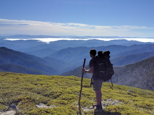
It wasn't long after leaving that we had cleared the tree line and the amazing views we were expecting started to appear.

Looking north east you could clearly see the Kosciusko Mountain range with snow on the higher peaks. We were all stunned with how beautiful the scenery was with the clouds lingering between the mountains below the pristine blue sky's.

Patches of snow were also present on the south and east sides of Bogong as we snaked our way up the final steep rocky section of the Eskdale Spur.

Kell taking in a last rest stop before making our final ascent.
A little after 9am we were at the top of the spur with the summit in sight. We downed our packs, grabbed a snack and started toward the summit cairn.

As we walked to the summit we couldn't resist playing in the snow and found it cool that it is almost summer, a very warm day and we were in shorts and t-shirt messing about in snow.

By 9.30 we were on the summit of the highest mountain in Victoria, Mt Bogong. We spent some time taking in the 360 degree views on a perfect spring day, taking plenty of selfies and getting the customary group photo on the massive summit cairn.

As we made our way back to our packs we could clearly see Victoria's second highest peak, Mt Feathertop in the far distance as we were trying to work out what ridges we were going to walk in the next few days.

We said our farewells to Paul, Kell once again apologizing for making him sick, and we started our way toward Cleve Cole Hut. Every step from here for the next few days was uncharted territory for us.

The walk from along the ridge past Tadgell Point to Cleve Cole was was very easy and pleasant. There were some great views to the east over some cool jagged rocks. Once we hit the tree line we knew we weren't far from Cleve Cole. Just before the hut we come across a large group of teenagers lead by a couple of guys in their 70s making their way back down to the bottom of the mountain.
Shirts open and full of fun the guys told us they left some sherry and a couple cans of beer in the hut that we were more than welcome to help ourselves to. I did catch Kell having a sneaky perv at the open shirted aging adventurers.

We arrived at CCH about 11am. Blue skys, greens grass, where else would there be a better place to de-pack and have a look around and a rest.
The hut was cool, bunks, mattresses, a sink and a stove, was like a little house, and we found the beers Ol'Mate said we could have, so into the pack they went, as if my bag wasn't heavy enough.
We spent about 30 minutes checking out the hut and of coarse Kell was chasing lizards, but by 11.30 we were on our way again

Before long we were crossing a small creek and like always I cant resist, I have to fill my water bottles, there is just something about cold, clear mountain water, cant beat it.
It was about 12.30 and we had made it to the AAWT. (Australia Alps walking track). We had arrived at the section of the walk that I knew would test us and had no idea how long it would take us.

We had 9km left to go today, 5km down hill, a river crossing then 4km up to Roper Hut, the cruisey morning we were having was about to come to a complete stop.
We headed off down T Spur and were quickly surrounded by the burnt and regrowing snow gums.

The 5km down T Spur was a bit of a drag I think, not a lot of scenery apart from one or two nice views out to the east, and there were a lot of fallen trees that were making hiking with big packs on a little difficult.
By 2:15 we had reached the bottom and knew it was the perfect time to de-pack and have some lunch before crossing Big River.

There was a cool little camp spot on the river, as always in the area, full of ants but nice to find some shade, it was starting to get really warm.

By 2:45 it was time to cross. We had been reading for months that Big River was huge and that it shouldn't be crossed till at least January but we wanted to have a look and were willing to turn around if needed. I had been stirring Kell up for weeks saying it would be up to out chins, it wasn't quite that bad.

Knee deep at the most but care still had to be taken as it was flowing reasonably hard and I could see someone going over if not careful.
The boots were off and the crocs were on, great footwear for these types of crossing, and fashionable, the perfect shoe really.
For the first time on the trip Kell did ask for some help. She would have been fine but wasn't confident carrying her bag across the river, Brent and Kev to the rescue.
We geared up and were on our way by 3pm with only 4 km to go, easy right.......um, big time no.

What can I say about the next 2 and a half hours of hiking. Probably the hardest we have done. It wasn't the heat or the climb, we have tackled longer steeper spurs, but on this day, Duane Spur was a nightmare with fallen trees across the track. Everywhere. I don't think they stopped. Walk 10mt, climb a log, walk another 20, crawl under a log. It went on and on as we were draining our water supply and praying for the end.

Rest stops were big time needed as this mother of a spur sucked everything out of us. It just didn't seem to end and I was constantly on the look out for the shinny tin roof in the distance that would be Roper Hut.

Duane Spur was a bitch.

Drained, tired, it finally come to an end at 5.30 pm, we had made Roper Hut. We said hello to the 3 guys that had set up camp 100 meters from the hut and we would have normally stopped for a chat, but we wanted to sit down, boil some water and relax with a coffee.

Before I de-packed I had a fear that I was afraid of had just come true. My heart dropped as I walked around the hut and realized that the water tank I had seen in the pics was no longer there, there was nothing, and we were running low.
Our mood dropped, we were spent and were now rationing our water supply trying to work out how far we had to walk tomorrow before we could refill.
Brent went over to the fellow hikers that were set up and come back with a smile on his face. 100 meters behind the hut was a fast flowing creek. Sickness in the stomach turned to delight as we all donned our crocs with the style police Kell putting on her fancy light weight shoes, we grabbed our water bottles and made our way to the creek.

I think I drank about 3 liters of water as we soaked our feet and cracked the cans of beer I had lugged all the way from Cleve Cole Hut. That half an hour we spent sitting in the creek was amazing. We were relieved we had water and astounded on the day we just had. This tiny little creek was a physical and emotional pick me up. Our mood turned as we had a fun evening cooking up a storm and reflecting on the day.
By 9.30 we were all in bed. Another big day tomorrow awaits.

We woke to a prefect morning, light winds, cool temperatures and a bright blue sky. Today was shaping up to be great.
We had our customary porridge and coffee and by 7:45 we were on our way.
Roper Hut was a great spot to stay, cool little hut, nice grassy camp spots, was wrapped we had a chance to visit here.

Before long we were at the Timms Spur track that would lead us straight to our camp sight at Bogong Creek Saddle, but I had read that it was a 4wd track that gets a little repetitive after a while so we continued another 2km and reached Spion Kopje Spur.

Perfect walking conditions on a flat track with no fallen trees saw us clocking a 4km/hr pace. We were cruising and within a km or so of walking west along Spion Kopje we were delighted to see huge patches of snow again just to the side of the track.

We couldn't resist walking through the snow with the occasional snowball being thrown at each other, and of coarse Kell trying to sneak a pic of my butt for her collection.
After some messing about in the snow we continued on the easy morning walking heading west bound along the reasonably flat ridge with amazing views in every direction.

As so as we had phone reception it was packs down and thumbs to the ready. Kev was messaging his dad for his birthday, Kell uploading pics on Facebook and Brent checking in on the home front. Before long, about 2.5, maybe 3km along the Spion Kopje ridge we hit water, and a lot of it.

It was a beautiful area. Snow in the background and on the distant peaks. Large grassy plains with fast flowing creeks well above the tree line. We had seen nothing like.

Before we continued on we made sure all our water bottles were full. I wasn't sure what would be available from now until we reached camp. I couldn't see anywhere where Grey Hills had water, and we were walking into the arvo with it starting to warm up quickly.

We continued along with ease, enjoying what this amazing ridge had to offer with the plan to drop packs at the Grey Hills turn off and go have a look at the summit of Spion Kopje.

By 10.30 we had dropped our packs and were on the top of Spoin Kopje, elevation of 1841mt, and we were super impressed. We had amazing 360 degree views and spent some time taking in what this spectacular summit had to offer.

We sat and realized how lucky we are to be seeing sights like we do. Most people wouldn't even dream of doing what we do and miss out on so much.
I am pretty sure if ya look closely Kell was that impressed that she found it worthy of a selfie.

After being super happy we decided to take the time to see Spion Kopje, it was back to business and we had picked up our packs and were on our way along the Grey Hills track by 11am.
At first the track was no where to be seen from where the sign was but we could see it in the far distance and knew what way to walk, so it wasn't a worry.

I was sorta a strange start to the Grey hills track, no real track but knee deep shrubs that blanketing the ground. Still amazing views.

Between Grey Hills track and Timms Spur there was a start of the Big River and a very impressive water fall. This thing was long. We were estimating over a kilometer down the side of the mountain. Kev was in his element, and I don't blame him. We de-packed and had a good look from afar, making sure not to be eaten alive by the ants, like normal up here.

After the wonder of the water fall things did start to get tough. We had it easy all morning but that was about to change. It was hot and the track started to drop rapidly, into the trees, making it hard knowing that we had to climb back up within no time.

It was nothing like the previous arvo but was challenging at time. Like a roller coaster, but not really that bad. I think being our 3rd day and no real relief from the sun we were starting to become fatigued.
We stopped for lunch about 1pm a little before Grey Hills Knob. We didn't really stay long as we were baking but it was nice to rest up for a bit.

The remainder of Grey Hills was a little underwhelming. We were doing anything to keep the sun from frying us including putting my Survivor Fiji buff to good use. For once it wasn't there to look cool in a pic, quite the opposite.
By 3.30 we were at Mt Arthur and started our way down. This section was tough. The track was really hard to find in parts as the undergrowth seemed to have eaten everything in sight. We wondered off track on a few occlusions and to the amusement of the others, well mostly Kell, I did fall over a few times. "it's alright guys, keep going, I can get up myself" Bastards.
The top section of Mt Arthur needs a good cut.

By 430 we had reached the bottom and dropped packs at the Bogong Creek Saddle and instantly walked the few hundred meters to the fast flowing creek at the start point of Quartz Ridge.
After filling our bottles in the pristine mountain water we made the decision not to set camp at the saddle as it was still in full sun and there was an awesome spot for plenty of tents right at the base of Quartz near the intention book and next to the creek, perfect.

Kell checking out butts, again.
We were wrapped to be set up so early compared to the last two days. This gave us plenty of time to dust ourselves of and rest up a little.
Kev was keen to wander the 1km down the track to Big River to try his luck at fishing. I was happy to join him as I wanted to soak my legs in the icy water.
Worms were all that we managed to catch, after about an hour we were back at camp cooking some dinner on the fire Brent and Kell got going.

As always we chatted into the evening, reflected on the day and prepared ourselves for the day ahead. I was good reminiscing to Kell about all the hikes we had done over the years, the good things, the bad things, good memories. She is part of them now.
We woke early as we wanted to be on our way by 7:30. The packs were feeling great as our food was diminishing and my snack bag was close to empty.
By 7:15 we were on our way. Mixed emotions. Sad that today was our last day, glad for a hot shower and a comfy bed. The mood was somber as we started up Quartz Ridge.

From the start it was tough going. The fallen trees that had haunted us on day two had returned. They were not as big but there were hundreds of them to weave our way through.
We past the Cairn Creek Hut turn off and continued up. A couple of kilometers in the fallen trees were disappearing and the great views were were falling in love with were returning.

We soon broke the tree line and was at Quartz Knob looking out with amazement on where we had been the last few days.

You could easily see Spion Kopje, Grey Hills, they all looked so far away and we started to feel a great sense of accomplishment on what we had achieved in the past 3 days.

As we continued to climb the wind picked up and the chill in the air was bitter. We all put another layer on it started to get really cold but the sky remained, like it did for the past 3 days, a beautiful blue in color.

Once again we hit snow and as always we found the need to walk right trough it even though it was well of the track. Was a good chance to rest up, have a bit of fun before the last couple of kilometers to the summit.

One of the members of the group, who shall remain nameless, asked the 3 guys to walk on ahead over the hill out of view so she could see if she could turn the snow yellow, and to top it of, take a pic of her attempt. Um, nice work.
Okay, moving on. By 11am we had finally, for the second time in 3 days, climbed to the highest point in Victoria, it was good to de-pack and take a breather.

We were blessed with the views we were seeing as I've been here before with zero visibility and its not fun. We also met a lone walker who had just reached the summit from up the staircase and was delighted to make it.

After a few more pics were were once again on our way and starting the decent down the awesome Eskdale Spur.

It was at this time when I started to reflect on the trip as I knew we only had a couple of hours before we were in the car heading home.

I wanted to pay respect to the crazy hair that joined us on the trip. Kell with her redder than red mop like fro was great if we were ever in trouble and needed to be spotted from the air, and Kev donning the cut off straw hat reveling a thick bed of hair that could easily be used to take a spark from my flint to start a fire.
The thinness of my hair means I would be burnt in two seconds, and without a hat, Brent just needs to hear that the sun is out and his pasty white skin will fry like an egg.

We made our way down the rocky and steep Eskdale with the views to the north stunning as the sea of mountains seemed to go on for ever. It was warm but the walking was pleasant and we were making good ground.
We arrived at Michell Hut by 12pm, half expecting Paul to still be there but he was long gone. The visitor book did have a few entries since we were there a couple of days ago. We stopped for our final rest before the last few kilometers to the car.

As we got closer the the bottom we past a few groups of struggling walkers heading up. It was hot and the day was getting on, not sure they realized what they had got themselves into. Hope they went ok.
Cut, bruised, battered, sore but extremely proud we were in the car heading toward Mt Beauty by 1pm to fuel up and grab a drink of anything other than water. We usually have drinks waiting for us in the car on our return but they were with Paul, so long gone.

I would say this was both the most pleasurable walk we had done, but also the hardest. There were elements that pushed us all to our limits. The huge mountains to climb in the heat while trying to navigate ourselves under and over large fallen trees with packs on was tough. This was all forgotten with the breathtaking views we had each day and the diversity of the terrain.
When you are up there you feel a world away from everyone and everything. Its hard to believe we are only 4 hours from Melbourne but at times feel as though we are on another planet, its pretty amazing.

Huge double kudos to my walking companions. Brent and Kev as always are the perfect hiking buddies and never complain when the time nazi I am kicks in and starts pushing everyone to get moving. Great blokes and awesome company.
To the new kid on the block. Kell. Wow. impressed the crap out of me. She didn't struggle at all, didn't complain, didn't slow us down, did amazing. She went in to this hike very nervous and was thinking of pulling out. I'm not sure now we will be doing a hike without her, she had a ball, we all did.
Wheels are already in motion for our next adventure and I cant wait to once again load up the pack and walk into the wilderness.


